Sunday, 6 November 2011


Maar Map imposed on 1859 Horchester map of Auckland's volcanic field.


My aim for the maar map was to place an emphasise on the points in Auckland's volcanic field which converge with Auckland's waterbodies. Water and volcanoes are two of the most defining characteristics of our city, yet there is a seperation in their relationships.

When we view a map of Auckland, say on Google maps, we cognitively place the volcanic cones we recognise from our own  spatial experience of Auckland where they are indicated on the map. The way in which we are accustomed to reading a map allows us to cognitively place spatial experience with a diagrammatic delineation of the place in which we are imagining.

"There is no spatial representation free of spatial conception."

The image above compares the 1859 map of Auckland with my own reductive version of the Maar Map. The relationship between these waterbodies are the same as the older map. However any other indication of spatial experience around them has been removed, including the actual coastline, roads and property boundaries etc.

The maps we commonly use today are becoming furthermore reduced of their illustrations of spatial experience, that is why I have chosen Google as a point of reference with the symbol used to indicate the centre of the given place in which you enter your search. The symbol has the power to reduce more literal spatial conceptions of the map. The blankness of the surrounding map not only emphasises this power but seperates the maars from other features in order to exclusively highlight their network.

 We are accustomed to reading this symbol as the centre, to which we attach the surrounding spatial qualities that we may have experienced. My aim is for this symbol to reference the reductive nature of the contemporary maps we use and have access to basically anywhere with an internet connection. These reduced maps, to verying degrees, rely on our own spatial conceptions of a place in order to function.

Therefore, as a contemporary verson the 1859 map, the commentary made with the comparison highlights the disconnection of the Maar as volcanic features from their surrounding network of volcanic cones. We can see the maars outlined on the 2D Google map which we associate to the actual waterbody, and we can see the volcanic cones we associate with their indication on the map as we imagine Auckland in perspective. Being able to see the cones looking across the city allows us to understand their relationships within a network. A network in which the maars are not a part of due to the significant difference in physical form.

The maar map does this in reverse, by exclusively showing the quantitative relationships between the maars which can only function as existing in a network in their 2D representation (unlike the volcanic cones which we can compare to one another by experiencing several at a time in perspective). Coupled with the Google symbol of the centre placeholder, we know to situate these waterbodies within the wider network of volcanic cones and of course Auckland itself.


[Quote taken from reading: 'Mapping Experience' by Marc Treib - Design Quarterly 115. The argument was informed by this reading.]

Wednesday, 24 August 2011

BOUNDARIES AND BORDERS


One article I read in this book was titled 'Boundaries and Borders', by Richard Sennet. He makes an impressive parallel with the notion of city walls, as literally being fortifications in historic cities with it's modern version being areas of cultural, communicative, economic exchange.

The antitheses of this ephemeral wall where differing communities exchange in the urban context, is that of a 'deadening wall'; such as a motorway, inner-city traffic, seperation of state housing (London). The writer describes these opposing elements as boundaries and borders; where Borders are zones which are articulated to allow the exchange of urban ecologies, and boundaries have this effect in adverse, repeling integration between urban ecologies.

This can be applied to the urban edges of waterbodies. Richard Sennet uses the example of the Thames bank becoming gentrified and gradually sealing out the lower socio-economic estates that did not sit on the river's edge; forming 'boundaries' rather than 'borders'.  

Perhaps this can be a more specific area of investigation of the coastlines of the maar waterbodies in Auckland?  An analyses of privatisation of the edges, activities that occur and physical state of the maar in relation to it's 'boundaries' or 'borderlines'. 


.


'The viewing of water is a solitary act, the regard of nothingness;
in viewing water man turns his back, literally, on the conditions which support his life.'


- Daniel Burnham 1909


Tuesday, 16 August 2011

Auckland's Volcanic Field.

 
1850 map of Auckland Isthmus and volcanic field. 


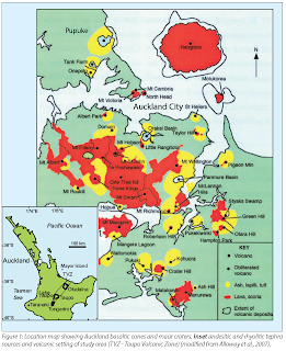
Location map showing Auckland basaltic cones and maar craters.


As we know, Auckland sits upon a vast [largely active] volcanic field. It is the geomorphic setting that has shapped the region and the isthmus. I have become interested in the water bodies [maar craters] that were formed by volcanic activity, therefore a part of the network of the volcanic field.
This is a possible area of investigation. Apart from the visual markers of our geological history [that being the volcanos dotted around Auckland], we can also acknowledge - and make connections with - the formation of areas of the coastline and subsequent bodies of water as a result of volcanic activities.

THEREFORE:  potentially allowing the mechanism for the formation of our region and natural landmarks to speak to another realm of urban interaction with landscape, that being the water-bodies of the maar craters.


Volcanic Waterbodies.

A maar is a broad, low-relief volcanic crater that is caused by a phreatomagmatic eruption, an explosion caused by groundwater coming into contact with hot lava or magma. A maar characteristically fills with water to form a relatively shallow crater lake. The name comes from the local Moselle Franconian dialect of Daun, where it is in turn derived from Latin mare (sea). Maars are shallow, flat-floored craters that scientists interpret as having formed above diatremes as a result of a violent expansion of magmatic gas or steam; deep erosion of a maar presumably would expose a diatreme. Maars range in size from 60 to 8,000 m (200 to 26,000 ft) across and from 10 to 200 m (33 to 660 ft) deep, and most are commonly filled with water to form natural lakes. Most maars have low rims composed of a mixture of loose fragments of volcanic rocks and rocks torn from the walls of the diatreme.

[wikipedia]


In Auckland:  Lake Pupuke, Onepoto, Orakei  Basin, Pukaki Lagoon; are all examples of a 'maar'.